Contents
Index
Add Control
The add function allows you to create a new control point.
Point Number
Click on the point to which the control should be attached, or type in the point number.
The current coordinates of the point will then be displayed
Name
Enter the Name of the Control Point.
If the “Master File” option is to be used, be careful that the name of each control point is
exactly the same as its name in the Control Point Master File.
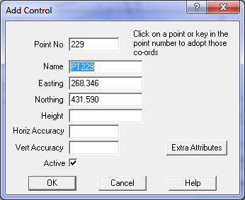
Easting
Every point must have an Easting (X) value, and it must be on the same datum and zone as
the other control points in the job.
Northing
Every point must have a Northing (Y) value, and it must be on the same datum and zone as
the other control points in the job.
Height
The height (Z) value for the point is optional.
If a point has no height value, this field will be blank.
The adjustment uses the value of the nearest control point to compute the height
above sea level correction for parcel lines.
If there are no control point heights, it is assumed that this correction need not apply
Horizontal Accuracy
The horizontal accuracy field is not used by the adjustment at this stage as all active
control points are assumed to be fixed points.
Vertical Accuracy
The vertical accuracy field is not used by the adjustment at this stage as all active
control points are assumed to be fixed points.